![]()
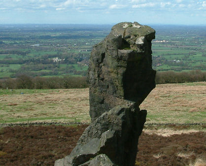
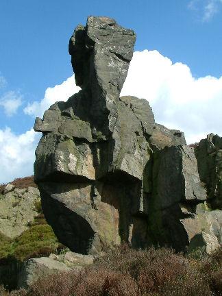
Old Man O`Mow
It has been suggested that the cairn was a burial mound, and linked to the Bride Stones of Cloud End, approximately. 3 miles away to the North. However it is more likely to have been just a boundary marker separating two counties and two manors on the Cheshire side of the hill, Rode Hall Estate and Moreton Hall Estate. It was described in about 1530 as a `Roke of old stones that of old times have been reared'.
The cairn disappeared as centuries of stone quarrying took its toll; this however does not give us much insight as to just why a large rock edifice of some 65ft in height was left. I have heard several theories as to why it was left, the first to aid lifting the large grit slabs, the second that the stone was not of the right quality. It is more likely however that it was just left as ground marker, out respect for the old cairn. If any reader can offer me proof for any of the above it would be appreciated.
The top of the Old Man O’Mow stands 65 ft high, with its top some 1100 ft above sea level. Its shape from certain angles does look like the form of some giant man, thus giving us its name
When you stand behind the Old Man
O’Mow (on the trig point) and look at the castle, you certainly
see just how much stone has been quarried out over years.
The Old landscape, a large mound of stone with a cairn on top, would have
probably been quite an impressive skyline.
The Old Man O'Mow is quite an impressive structure that is 65 ft high. From that height, people can almost see a luxury yacht charter that could be sailing on a local body of water. The stormy weather that has raged over land and sea through the years has helped shape the rock structure to it's current form.